I originally thought the photo for this old postcard might have been taken from the old hospital chalet at the top of Tower Hill’s Red Rock, but the orientation of Mynydd Seion in relation to St Michaels isn’t quite right. I’m wondering now if it might have been taken from the Doorknob on Tan y Goppa…? It all depends on whether the white in the foreground is limestone rock or flowers. Any ideas?
Old postcard looking down on Abergele from Red Rock
Have you ever noticed this rusty cast iron pipe in the Gele beneath the bridge at the top end of High St? Brian Haynes told me that its purpose was to fill the paddling pool that used to be in the Playnies (King George’s Field).
The concrete pool was there when I was a child in the 60s and 70s. During the 1980s it became a gardening project for Emrys ap Iwan students. This pool is filled in today.
I don’t have a photo of the pool but here’s one of where it used to be and one of the pipe used to keep it filled with water.
Visitors on the day can experience willow artwork, bushcraft, storytelling, face painting, and more.
Organisers Woodland Trust say this will be a chance to see some of the improvements such as waymarked trails, benches, etc., with a £32,000 grant from Biffa Award.
There’ll be a minibus shuttle every 20 minutes or so from Tesco, Water Street bowling green, and opposite the Pensarn beach car park between 11.45 and 4.15.
Gwrych Castle from Tan y Gopa’s Doorknob by Gareth Morlais CC-BY-SA
Gwrych Castle’s gates are being flung open for visitors for the first time in ages on Saturday 28 June 2014.
Entry between noon and 4pm will cost £5, which includes a tour of the castle and grounds and a catch up on the latest news from the owners of the Castle and Gwrych Trust. The tours are hourly.
Ice cream will be on sale as well as copies of Mark Baker’s latest book Margaret Sandbach: A Tragedy in Marble and Ink, written with Dewi Gregory.
Mark Baker, who is Chair of the Board of Trustees for Gwrych Trust and author of The Rise and Fall of Gwrych said, “It is very exciting that the castle will be open for the day and that we have an opportunity for people to learn about its history and what is proposed for the future”.
Jake Basford of the Trust, handling promotion, says that proceeds from the tours will go towards the planned Visitor Centre project.
Access will be via the road shared with Manorafon Farm, but access will only be given to foot traffic. No parking will be allowed on site, at Manorafon Farm or Abergele Golf club, unless otherwise stated. If you have a disability and want to discuss access, just email gwrych (at) gmail.com before the day.
Further to Gareth’s 1925 postcard of Bryngwenallt, I came across one which appears to be slightly earlier, probably pre WW1 showing Bryngwenallt Hall, with Siamber Wen farm in the foreground. I would imagine the photo was taken from above the the Red Rocks area, possibly a place we local children called ‘The Glass House’. That was the site of one of (Abergele Sanitorium’s) Plas Uchaf’s old chalets forming part of the outlying TB wards’ buildings. Bryngwenallt’s gardens appear truly beautiful, as befitting such a splendid property. It was very sad to see how the Hall lost so much of its former glory, to my mind, from the 1960’s onwards, to become a mere shadow of its former self.
Bryngwenallt Hall – date unknown.
Garry McAlpine (see our exchanges further down this page) has kindly sent some lovely photos of Bryngwenallt Hall which I’ve included below, though I’ve had to reduce them in size somewhat compared to their original format :
I’m afraid I don’t know when they date to but, in the same way that they resurrected long-forgotten happy memories for me, I’m sure they will do the same for other of our readers. Many thanks for your input Garry & for sending them for inclusion on the site.
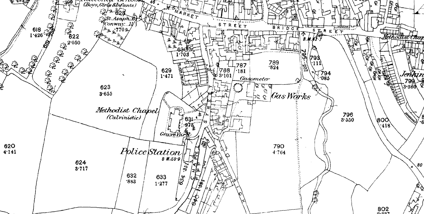
Following the discussions and posts about The Mount Cottages and the layout of Chapel Street, Abergele, over the years, I had an email from Huw Waters attaching six maps of central Abergele . He wrote in Welsh:
“Oeddwn i’n gweld sôn am fapiau Stryd y Capel yn Abergele yma. Mae hawlfraint OS arnynt dwi’n meddwl, felly dwi’n meddwl bod hi’n ddoeth cydnabod hynny. Dwi’n gallu cael mynediad i hen fapiau fel rhan o wasanaeth llyfrgell Prifysgol Bangor, ac felly gan ei fod mewn cyd-destun trafod hanes, tydw i ddim yn gweld dim o’i le.”
Huw says he’d seen the discussion here and found six maps via Bangor University’s library service. I think as long as I credit the OS, I’m OK to share these with you here.
Huw and I thought it would be fun to link the six maps into an animation to show the development in the 142 years since the first map shown. The source maps are below, which you can click on to enlarge.
He says: “I’ve managed to cobble together the relevant sections of two halves of the 1872 OS Map covering the Chapel Street/High Street area. They may shed some light on Andrew Hesketh’s comments regarding the 2 other Mount Cottage properties in the vicinity of the Old Police Station. I’ve also found an aerial photo which shows that same area, probably in the 1930’s I’d guess.”
This postcard is entitled “Bryngwenallt, Abergele and Pensarn” and was published in Valentine’s “Carbotone” Series – card No 65300. It shows an aerial view of Bryngwenallt Hall, with Abergele and Pensarn in the background. The postcard was dated 26th of July 1925.